


Easton Hill, Clumps and Barrows
- Paul Timlett

- Jul 1, 2024
- 14 min read
Updated: Nov 13, 2024

Long term followers of Hidden Wiltshire will know how much we like our bottoms. But a nice clump comes a close second. And that is what attracted me to this part of Wiltshire whilst I browsed the map looking for a suitable place to walk. My eye was drawn to some hills where I had not walked before, in amongst which the map revealed the existence of several clumps. This was to be the start of what became a memorable day, both for good and bad reasons. A day that revealed the best and the worst of the Wiltshire countryside.
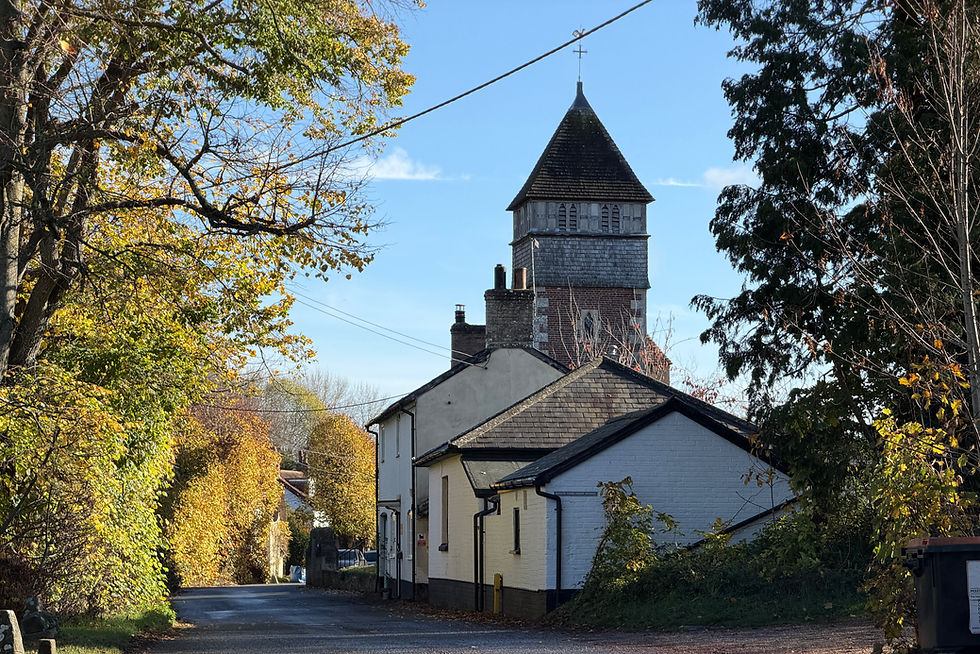
My walk began on a roasting hot day in the lovely little village of Easton Royal, to the east of Pewsey. As always I headed to the church in search of a parking place and I found ample parking on the roadside here. The church lies towards the end of a no through road so there is very little traffic. The lane is lined with pretty, whitewashed thatched cottages that lead you towards the escarpment of the hills above.

For family reasons I’ve been spending a lot of time in East Sussex recently and this so reminded me of some of the villages at the foot of the South Downs, and one in particular – Firle. The vicar there is something of a minor celebrity having featured in a number of TV programmes over the years. I recently saw him sitting outside a café in Lewes and I’m not sure his behaviour was becoming of a man of the cloth! Look him up and you can make up your mind what you think of him but he does have a beautiful church.
Pretty much every walk I do will involve a visit to a church, and this one was to be no different. Since the car was parked just outside I visited twice both at the beginning and the end of the day. The Holy Trinity Church that stands before us today is relatively modern compared to so many churches in Wiltshire, dating as it does to 1591. Its predecessor was pulled down before it fell down! The exterior is peculiar in that the tower, a more recent addition, stands to one side on the south of the building.

Like so many churches now the churchyard is being managed as a wild flower meadow in parts but what I loved about this one was that it is being properly managed – they haven’t just not mowed the grass. A plan on the notice board shows how the different parts of the churchyard are being gardened and when. The interior is quite plain and delicately lit, the lack of traffic outside making it a calm, tranquil place to sit.

As ever I’m always struck by the plaques on the walls of our village churches listing those who served in the First World War and Holy Trinity was no exception. The sheer number of men who went to war from this little village was horrifying, many of whom did not return. Several shared the same surname. Such a waste of humanity.

Tearing myself away from the shade of the church I set off on the day’s walk heading south down the lane towards the hill rising above towards the first clump of the day – Easton Clump high above the village on Easton Hill. The lane turns into a byway and at a T-junction there is a choice – you could do the walk clockwise or anti-clockwise. I had planned the walk to go clockwise but before taking the byway to the left I had to stand aside for a Balfour Beatty pick up truck. Curious. On reaching the T-junction I saw along the track to the right a truck and workmen standing around it. Curiouser and curiouser. Then I noticed a National Grid sign on the farm gate into the field opposite the junction detailing the work being done on the power lines. This is part of the 82 km Bramley to Melksham upgrade to the transmission lines. What struck me was the irony that here the new pylons were nearly twice as big as the ones being replaced. Truly hideous structures. Whilst at the same time at Roundway just outside Devizes the pylons are being removed and buried underground – all part of the same scheme. So what’s special about Roundway?
So taking the turning to the left I followed the byway, which is more a dirt road here, heading east until a bend heading right and south took the byway steeply up the escarpment towards Easton Clump at the top of Easton Hill. And here I found a sign that was to become something of a puzzle throughout the day. A large red road sign said “Footpath Closed”. Another smaller sign nailed to a post said it was closed between 30 May 2024 and 20 June 2024, and again between 19 August 2024 and 2 September 2024. Today was 26 June so I ignored the “Footpath Closed” sign. The byway (not a footpath) passes underneath the overhead power lines so you can see why it’s necessary to close the right of way. However, during the course of the day I passed several notices on the affected byways all of them showing different closure dates! A couple of kilometres further along this byway is another notice saying the right of way was closed until 26 June ie today!
I continued upwards along the byway, starting to feel the heat which was to reach 28C during the course of the day. The views behind and to left and right gradually opened up and became more breathtaking.

To my right, looking west, in places it was possible to look across through the hedgerow to the terraced hillsides on which sheep grazed. Sadly the ubiquitous “Private” signs dotted around showed the public is not welcome here, mainly because the hillside is reserved for the shoot. But as I peered longingly over a forbidding looking fence all I could hear was linnet and willow warblers signing in the morning sunshine.

The byway snaked its way up the hillside, eventually flattening out to the east of Easton Clump. On the map can be seen earthworks and a circular structure which Historic England say is a disc barrow dating to the early Bronze Age between 1400 and 1200 BC. Again, as with so many of our ancient monuments, it sits on private land so is inaccessible. However, an open gate giving way to a track on my right suggested I may be able to reach it. However, after some distance the track turned away from the clump so I spent some time here chatting to a field full of young cattle on the other side of the fence and watching a brown hare on the track a short way away.

Returning to the byway, and by now on level ground, I began the 2 km walk south towards my next objective – Crowdown Clump. By Hill Barn and the Pump House the byway becomes almost completely overgrown, perhaps due to the lack of use during the closure of the byway. The grass was waist height and the deeply rutted track difficult to see, risking a turned ankle. However, there was no fence on either side and the farmer had left a wide field margin or headland so I walked first one side then the other on the adjacent bare field margins. I’d like to think the farmer has left these margins deliberately – chatting to a local farmer recently he said there are subsidies available for doing this but the process for claiming them is mired in red tape which is why so many farmers don’t leave a margin. But I was grateful to this particular farmer nonetheless.
The fields either side of the byway were vast areas of monoculture with very little if anything growing other than the arable crop (wheat on this occasion). Not far from the byway on either side are marked tumuli but these have long since been ploughed out and there is no evidence of them now. The byway follows a shallow valley and low hills rise either side, Easton Clump ever present behind and Crowdown Clump ahead up to the left.

This clump is a short distance from the byway but I’d read that the farmer had left access to it open from the byway. I soon found a double farmgate with a wide gap beside it allow ample room for a pedestrian or rider to pass. I needed no further invitation and followed the field boundary to the clump which also bears the name Godsbury.
Crowdown Clump is a defensive enclosure dating to some time between the seventh to fifth centuries BC. It is in a prominent position with views across the Bourne Valley below. Nowadays it “measures approximately 93m long by 63m wide with a single rampart bank standing 0.5m high internally surrounded by a largely buried ditch which has created a scarp of up to 1.2m high on the outer side’ according to Historic England. In the Saxon charter of 971 AD it was called ‘Guthredesburg’, and by 1773 is was known as Godsbury. I walked around three sides of the wood in which Godsbury now sits and found it thick and impenetrable. There was nothing to be seen of the structure within. So I sat on a small mound of straw drinking coffee whilst I took in the views around me. I had planned to return to the byway but realised that I was sitting right next to another byway that drops down to the A338 and the River Bourne to the north-east. So I decided to follow this byway south-west where it joins with the byway I’d been on earlier.
As I descended what was one of the white dirt tracks that is typical of this part of Wiltshire I could see Sidbury Hill on Salisbury Plain in the distance. As I admired the view an RAF A400M transport aircraft flew right to left in front of Sidbury Hill, its rear cargo door open. I knew exactly what was about to happen. As I watched a large container emerged from the back and descended on a parachute to the Plain. The aircraft then banked left and again I was prepared for what was about to happen. It executed a 180 degree turn that would bring it low and almost directly overhead.
I’m a bit of an aircraft geek so it was great to get such a close view. It then turned another 180 degrees and made another run across in front of Sidbury Hill, its cargo ramp still open. This time four parachutes emerged.

Contnuing my journey I loved the way the track twisted its way down the hill, the view ahead changing at each turn. A small open sided barn came into view.

As I neared the foot of the hill at the junction with my earlier byway I heard behind me the unmistakable sound of something else in flight – this time a flock of lapwing. My camera is pretty much always at the ready so I snatched a photograph as they lifted up and away from the field behind me.

At the bottom of the hill by what is marked as Falstone Pond (which I could not see) next to the barn I’d seen a little earlier, the track headed upwards. It was here that I came across the only other person I was to encounter all day during the walk. A chap came up the hill on a motor bike, politely slowing to a crawl as he passed me. He gently accelerated away and was gone. At this point I was feeling all was well in my little piece of the planet. But that was about to change.

As the track levelled out again I was looking for a short stretch of bridleway on my right across a field leading to another byway which I would be using later for the return journey to Easton Royal. What I found was a locked metal farm gate behind which was a dense crop of rapeseed. No attempt had been made to clear the right of way, or to allow access to the field. As I took a photo and made a note of the coordinates for my report to Wiltshire Council I felt a painful sting on my leg, followed by another (I was wearing shorts). I then saw blood running down by leg. These were the first of many bites from horse flies that I was to suffer through the rest of the day, attracted so it seems by rapeseed. I fled the scene, making for a junction of the two byways a few hundred metres away. Here I could turn right almost 180 degrees and follow the byway back to the point where the bridleway should have emerged from the rapeseed field. At this juncture I found another similarly padlocked gate. My plan was to follow this bridleway south-west along the edge of Oldhat Copse, in the hope of reaching Oldhat Barrow which I had read was also accessible despite it appearing to be on private land.
Within a short distance along this bridleway the dreaded rapeseed returned on the south side of the wood marked as The Scrubs on the map. It had been planted in the margin of a field of barley. Call me cynical but this appeared to be a deliberate attempt to obstruct the right of way. Anyone who has tried to fight their way through rapeseed will know it is all but impossible. I tried to make headway but had to turn back. A close look at the OS map suggests the bridleway passes through the wood but there was no way into it. I tried to enter The Scrubs but it was so dense it too was impassable. By this time I was hot and being further bitten by horse flies. I was now very angry! It’s times like this that I have absolutely no issue with trespassing so I did so. After what seemed like an eternity I eventually found my way to Oldhat Barrow, by now not just bitten to death but covered in cuts from the brambles I was trying to fight my way through. To my surprise at Oldhat Barrow I found it surrounded by MOD signs. At some point I had entered part of the Salisbury Plain Training Area and I was in woodland where I’m not sure I was supposed to be. However, I was there so I took some photographs.

Oldhat Barrow is a bowl barrow – a ditched round barrow from the late Neolithic early Bronze Age. It is remarkably well preserved as so many are on Salisbury Plain. The mound is c.40m diameter, the ditch 3m wide and the outer bank 3m wide. The overall diameter is c.52m. As you can see from the photograph the mound still has some considerable height if you look at it in relation to the trees behind it. I still don’t know whether the public are allowed to access the barrow but I had seen a few photographs of it before my visit so others have been there before me. The woodland is more open here and with wide tracks through it within a few minutes I was on a track on the western edge of it. Since this is on the Salisbury Plain Training Area and not within a live firing area I was pretty certain I was permitted to use this track. So I used it to return to the other end of the bridleway I’d tried to use earlier, arriving at it at the south-east corner of Cow Down. If you head south-west along the bridleway you reach the road between Pewsey and Everleigh that comes up over the hill past the Pewsey White Horse.

The woodland here, Oldhat Copse, was absolutely delightful. The dappled light from the intermittent sunshine penetrating the canopy above providing some welcome shade. I settled onto a log at the edge of the wood to have a late lunch, enjoying the tranquillity of the birdsong.
An army helicopter hovering overhead shattered the peace for a while but it soon left. Eventually I packed up but not before puzzling over some slabs of stone at my feet that had clearly been worked. Had there been a building here at some point?

From this point I turned north-east along the bridleway with some trepidation. I knew I would be faced with the impenetrable stretch of bridleway again but this time I had no other option but to go through or round it. On reaching it I decided I would have to just plough through the field of barley. I trampled the crop until I reached one of the tramlines used by the tractor. My earlier rage returned as it was clear the tramlines were bare earth. So the crop had not just been flattened by the tyres of a tractor but had not been sown at all or herbicide had been applied. This for me proved the point that the farmer had been capable of keeping the bridleway along the field boundary clear but had chosen to block it. On returning to the byway east of The Scrubs I took some more photographs and recorded my position for another report to Wiltshire Council of a blocked right of way.
This byway now descends gradually for just over 2kms almost north towards Easton Royal. This one too was subject to closures for the National Grid work. It was extremely overgrown in places, deeply rutted and bounded by fences on either side. Beyond the fence to the right was open meadow but the public are forced along this narrow corridor. I was once again plagued by flies that attempted to penetrate my brain through my eyeballs, up my nose and in my ears. Meanwhile my eyes were fixed on the ground trying to avoid a broken ankle. How on earth could anybody ride a bike or a horse along here, let alone drive a 4x4?

If as a pedestrian one were to encounter a Landrover coming the other way, getting aside could be a struggle. As you can tell I did not enjoy this part of the walk. Eventually passing a large barn and another pump house on the right I reached the end of the byway at its junction with a minor road, finding a number of brightly coloured beehives in the field at the junction.

Here I found a voluntary restraint notice nailed to a post at the junction. It seems that Wiltshire Council had requested that users restrain from using the byway I’d just walked along between November 2023 and May 2024! There was no sign at the other end of the byway where I joined it about 3kms earlier. This may have explained its parlous state, which despite the spell of hot dry weather was still boggy in places. It must be hell in winter.
However, my troubles were not quite over. The post had a bridleway sign pointing to the right and north-east on it. Sure enough there was wide gap in the hedge. But all I could see was a large field of barley, waist high. Once again no attempt whatsoever had been made to keep the right of way clear. So I took more photographs and recorded the location for what would be my third report of the day to Wiltshire Council of a blocked right of way. I then took a compass bearing, aimed for the end of a hedge line on the far side of the field and ploughed my way through the crop. Some way in I could see where someone else had done the same so I followed the faint trail across the field trying to avoid further damage.

Reaching the far side of the field another gap in the hedge revealed a narrow path where the bridleway continued. My anger soothed as this proved to be a delightful path dropping down the hillside in a hollow. I even found orchids, the only ones of the day, on the bankside. The views north opened up (which unfortunately included the power lines and pylons) and near the bottom a gate on my right revealed a view of the hillside where I had followed the byway up to Easton Hill so many hours earlier, offering a different perspective of the ancient field system I had seen.


A little further the bridleway turns right to join the byway which turns left back into Easton Royal. As I entered the lane back to the church the lowering sun perfectly lit the row of thatched cottages. I couldn’t resist a final visit to the church to reflect on the day.


The walk shown on the map shows the way I mostly ended up going, not the way I had planned. It’s 8.24 miles in total. 13.26 kilometres. It includes a leg out to Oldhat Barrow and back using the easiest route (not the way I went to it but it is the return route I used although I had to walk in the field of crops before returning to the byway east of The Scrubs). I still don’t know if access is permitted to the barrow.
Would I recommend this walk? Well after a few days to think about it (and after a few days on Piriton because of all the bites I suffered) I thoroughly enjoyed parts of it. The views are sublime and this took me to a part of Wiltshire I hadn’t walked before. The sense of prehistory is all around and I felt the presence of our ancestors on the long straight stretches of byway across open countryside with no signs of habitation. I love walking the chalk roads when it’s warm and the surface is dry. I also loved the solitude out there. Clearly I detest finding blocked rights of way and finding three on this walk made me very angry. I make my belief in increased access to the countryside very clear – it is a passion. And on days like this, when I see us losing so many of what few rights of way we have and being forced into using narrow almost impassable ribbons of the countryside when we could so easily just step outside these corridors without causing any harm, my commitment to improved access grows even stronger. So yes I would do the walk again, having learned what I did on my trial run. Just don’t forget the dates that the byways are closed for the National Grid work.


Update: 17.1.25
I actually did the walk today - without your diversions - with a couple of companions, and all paths were open and passable, despite lots of surface water and mud. The bridleway sign (above the Voluntary Restraint notice, which is still there) still points across a field bearing no trace of a path, until you get to the opposite corner of course. Oddly enough, earlier we did see a chap on a motorcycle in roughly the same spot where you saw him: maybe he does it every day.
Thanks again for an excellent post.
Great post thanks.Oddly enough, I’d marked out exactly the same route on my map - minus the diversions - for a future date.
My 2009 OS Explorer has those ‘Danger Zone’ red triangles around the Scrubs, Oldhat Copse and Oldham Barrow; in fact they follow the path you were on for a while for after the sharp turn right at the Southernmost point of your walk. But if the red flags are not flying, you can presumably walk where you walked.
Im always grateful to people like yourself who go to the trouble of reporting blocked rights of way to local councils. Thank you. It does look like a varied and interesting walk.